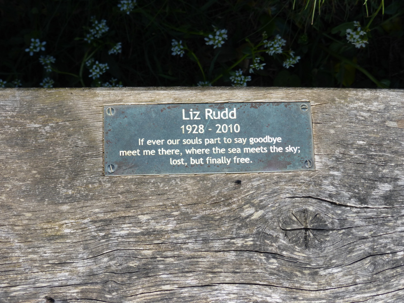
You have to love sand for this stretch of the cliff path; and it helps if you do not expect attractive architecture.
Leaving Perranporth is the best way of visiting as you do not have to look at the surfer-dude and concrete block ‘architecture’ for too long. Several of the towns on this north coast seem to have a generous layer of sand throughout their streets which helps to remind one what they are really here for.
 Passing some early-season surf lifesavers practising in the surf and many dogs being walked, we found the path rose up onto the top of the dunes. It was not for long, however, as it soon dropped down onto the beach of Perran or Penhale beach sands and we had a straight walk on the firm sand. This is a lovely stretch provided you can find firm sand to make the going easier.
Being down on the beach, one does not realise how large the dunes are behind the cliffs: about a mile inland of rough grass and sand. It was on this beach that St Piran surfed in on his millstone, climbed the cliffs and established his oratory and chapel. We were too focused on the walk to take a detour and left that visit for another time.

 Approaching Ligger Point there were signs warning us of a military danger area. A decayed camp appeared on the cliff top, cheek-by-jowl with some lovely ‘smuggler’ caves in Hoblyn’s Cove. A mysterious bunkhouse, said to be part of GCHQ, was accompanied by an almost artistic aerial on Penhale Point.
Holywell Bay continued the sandy theme. It is more compact than Perranporth but a lovely sandy bay with some very dull modern holiday homes in the village. One day there will be a (Cornish) law that such buildings cannot be left in concrete grey but must be white or some other traditional colour. Dull architecture is all very well but why compound the problem by getting the colour wrong?
 This is the point at which one really, really has to love sand for the climb out of Holywell Bay was worthy of an Arabian dune. Eventually, we reached firmer footing on the open cliff top where the thrift was flowering in profusion with a small scabious-like blue flower we could not immediately identify (later suggestion: sea squill or scilla verna).
These accompanied us all the way to Crantock Beach where the path once more crossed some grassy dunes and the way was decided by luck more than signage.
 Emerging on the banks of the Gannel, it was clear that we were approaching civilisation for the opposite – Pentire – bank was filled with smart houses whose estates tumbled down the steep cliff. Different solutions were adopted by the owners: meandering paths through vegetation, smart lined lawns to rigid modernity. We pondered on how often they carried food to the ‘sitting areas’ at the bottom of the hill, only to find that they had forgotten the salt, or wanted another drink.
Our path, devoid of modern buildings, led us through a whole field of cowslips where we lunched.
It was a short walk to Penpol creek and a low-tide crossing place . As the tide was out we were able to cross some strangely fluid sand and then cross and re-cross the small footbridge which is under water at high tide. We thus demonstrated that we had reached Newquay which will be a later starting point.
Honour satisfied, we returned to our car, ticking off another 9 miles of the Coast Path (over 10 miles on our gps). On the way home, we stopped off at Crantock and Cubert churches.


 Just out of town, we passed a cross to all those sailors who had been lost on this coast (see earlier posting about
  The cliffs here are steep but crumbling. Managed retreat seems to be the order of the day. The beaches below were covered in a multiplicity of differently coloured stone: greenstone, granite and even some unidentified white stone.
 pproaching Trewavas Head, we delighted in the engines houses which rival the Crowns at Botallack for their precarious position on the cliff edge. Signs warned us that choughs were nesting here. It is good to know that they are no longer confined to an unspecified, and deeply secret, place on the Lizard, but are spreading to other parts of the Cornish coast. The black birds that we saw were, of course, simply black birds: not a red beak or foot to be seen.
 Moving on, after a little snack, we arrived at the familiar sight of Rinsey. This is surely the craziest siting of a house on this coast. Perhaps they thought that if they built any further back from the edge then someone would build in front of them and steal their view. On the other hand, we speculated, with caves below and in a mining area, perhaps the house has an elevator or staircase straight into the cave below to make smuggling easier. The plot for a re-working of ‘The House of Adventure’ started to develop in our minds …


 What was planned as a short walk to ‘fill in’ a gap we had not covered actually turned out to be a rather fuller day than we had planned.
 Once past Gillan itself, the going was very easy over springy turf towards Nare Point where there is an National Coastwatch Initiative lookout: surely one of their more remote, even by their standards. Gurnards Head perhaps rivals it and has less shipping to watch.
 During WWII, Nare Point was the site of a dummy village complete with lights turning on and off to try and confuse any enemy bomber into thinking it was Falmouth, an easy mistake to make in the days before pinpoint navigation. In earlier times, the point was even considered for another Henrician castle to match those at Pendennis and St Mawes, no doubt protecting the entrance to the Helford. Perhaps it was dropped for it would be a bold captain who attempted to bring a large ship into the Helford, unless, that is, he was a Frenchman on his way to Frenchman’s Creek.


 side. The sea was calm and as clear and blue as one could wish.
 stunning view, wondering why we should bother to carry on. But we did.
 The going, by now, had the air of a National Trust-cared for estate with stepping stones and helpful advice on signs. We were clearly approaching civilisation again.
 This was a tough part of the walk, involving several descents – which are the easy part – and then steep ups. The first one was the descent below the ‘large white’ Polurrian hotel, down a set of steps which became spine-shuddering as much as anything because of the large drop entailed with each one. We walked them in the opposite direction later in the day and quietly cursed their creator who clearly had longer legs than us.
 As we approached the top of Angrouse hill, we could see a large monument on its crest. This was Poldhu where Marconi carried out his famous experiments which culminated in the message to America and then to the South Atlantic. A humble field alongside the path was where the aerial had been erected. I looked at the mobile phone in my pocket which seemed a far cry from those early days, just over 100 years ago, when he achieved so much pioneering work from this remote Cornish cliff.

 A couple of nasty downies and uppies tested our muscles and endurance but if a Jack Russell and Labrador could do it then so could we.

 It was the wreck of HMS Anson which moved Henry Trengrouse to invent the ship-to-shore rocket carrying a light line as a precursor to a rope. This technique, so simple in concept, eventually led to the saving of many lives.


 Our first sign of population was at Cadgwith, surely the most photogenic and famous fishing cove, tucked into a corner facing east: everyone’s idea of a Cornish fishing village from generations of calendars and chocolate boxes.


 Approaching Chynalls point we could see yet another large white ‘former hotel’ now converted to some other use, probably a care home. This promoted us to wonder at the way we put our old people in remote places with empty views of the sea when it might well be company and activity that they really desire.