Mawgan Porth to Padstow

151024 Mawgan Porth to Padstow 03
Mawgan Porth

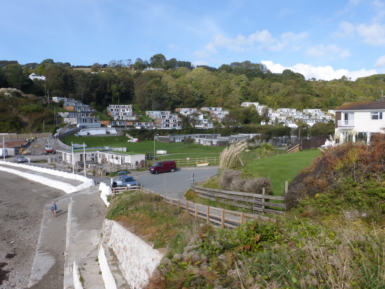
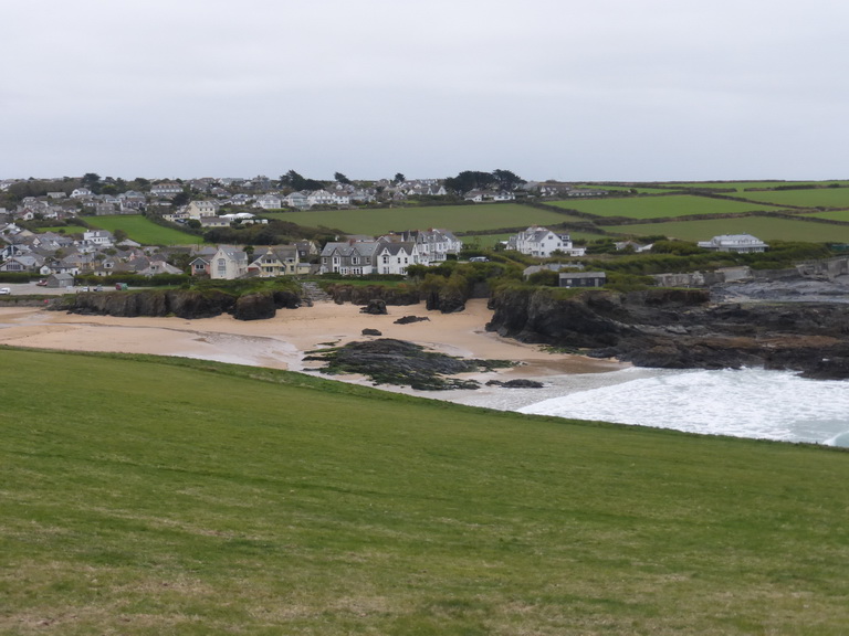
Having reached Cremyll ferry on the south coast, we returned to our exploration of the north coast, picking up where we left off at Mawgan Porth.

It was an overcast and blustery day. Gone were the azure blue seas and bright blue sky we had experienced last time we were here. In had come the mean seas of October.

We made a good start and left Mawgan Porth by walking across the sandy beach, marvelling at the shallowness of the beach, even with the tide out, the rollers breaking well out to sea. The Scarlet’s gardener was adjusting the planting and encouraging each plant to stand to attention.

151024 Mawgan Porth to Padstow 06
Bedruthan Steps

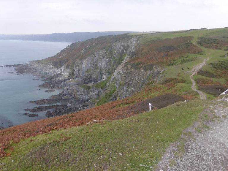
It was wonderful to be back on the north coast, though. The high cliffs, sheep-cropped soft grass and the towering cliffs were a contrast to the softness and density of population of the landscape of the Rame peninsular.

Any view over the edge of the cliff produced feelings of vertigo and were conducted by crawling on tummies to peer down at inaccessible sandy coves.

The gorse and blackthorn lay low on the ground and in places we passed great meadows of heather which must be a wonderful sight in the spring.

Bedruthan Steps are justly famous, having been a convenient charabanc distance from Newquay. The giant would have been proud of his legacy. As the surf and sand pounded against the columns, we wondered that they still managed to survive and had not been ground down by time.

151024 Mawgan Porth to Padstow 11
Across Porthcothan to the Trescore islands

Below us, a series of steep-sided coves rumbled to the road of the breaking waves and we spotted the first of many natural arches.

Around Park Head, we approached the Trescore islands -which tempted us to wonder again what makes them an island rather than a rock – which formed a tranquil  pool in an otherwise fractious sea.

It is a surprise that no one ever attempted to close up the gaps to make a small natural harbour.

151024 Mawgan Porth to Padstow 13Porthcothan, a long thin beach, was disappointing in not being able to provide coffee and so we made our way onwards passed a series of maelstroms, one of which was throwing spume up high and covering the neighbouring cliffs with white blossom like a field of dandelion clocks. The entire cliff face was plastered with ‘shaving foam’.

A welcome break in a YHA cafe in Treyarnon – highly recommended – provided the necessary coffee before we descended into the touristic area around Trevose Head, our eyes looking seaward to avoid seeing the golf course.

151024 Mawgan Porth to Padstow 17
Looking westward from Dinas Head past Booby’s and Constantine bays to Treyarnon

Constantine Bay provided some enjoyable sand-dune crossing but we were soon back climbing the grassy slopes to the head. Here we met our first enormous, almost circular, sink hole. It does not do to wonder too hard whether the rock beneath one’s feet is as friable as the rock in the sink hole must have been to have been worn away from underneath.

A brief detour to Dinas Head was essential and we noted the Coastguard pole, set here no doubt, for training in breeches buoys and similar rescues, the pole standing in for the truncated mast of a ship.

151024 Mawgan Porth to Padstow 20Rounding Trevose Head, a whole new vista opened up, stretching far to the north, a view that would no doubt become familiar as we made our way towards far-distant Devon.

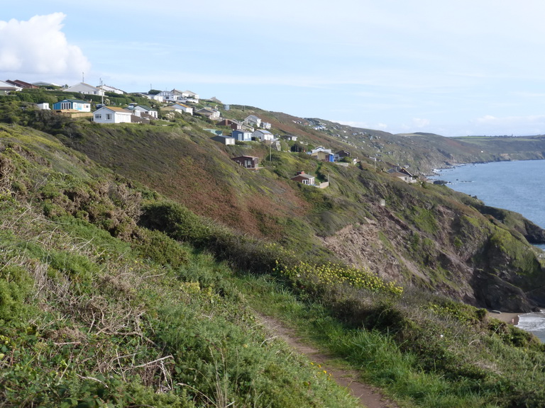
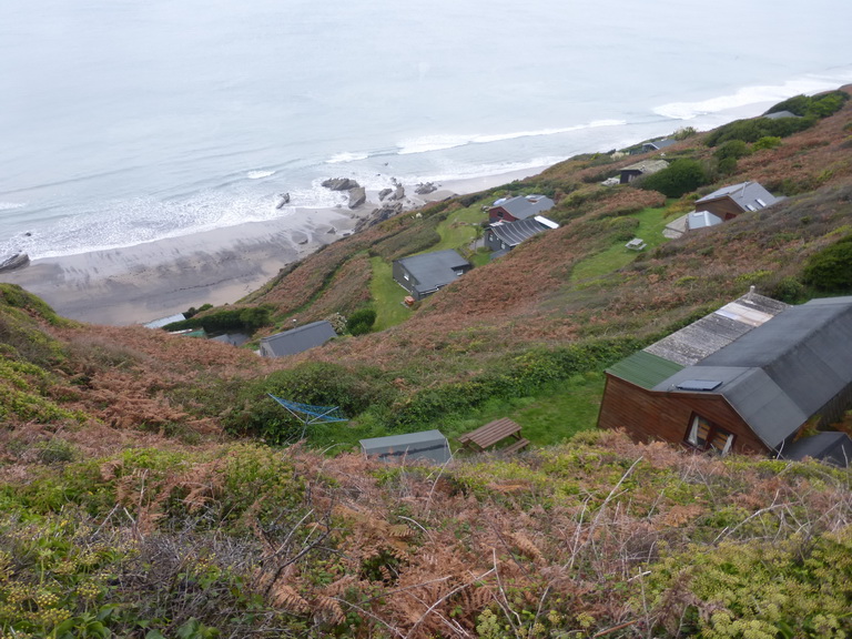
But close at hand was another less welcome vista: a quite ghastly mobile home camp right up close to the path at the back of Mother Ivy’s Bay. Why, we wondered, did the units have to be so close together; so close to the edge; so white when they could have been brown or green to blend into the landscape as we had seen at shack-land on the south coast near Freathy? What might have been a charming view was ruined by the proximity and massing of the camp.

151024 Mawgan Porth to Padstow 22
Harlyn bay and Cataclews point

Quite suddenly, the sun came out and great shafts of light shone like a powerful searchlight on sections of cliff and the sea. The familiar colours were back: a blue-green sea and watery blue sky.

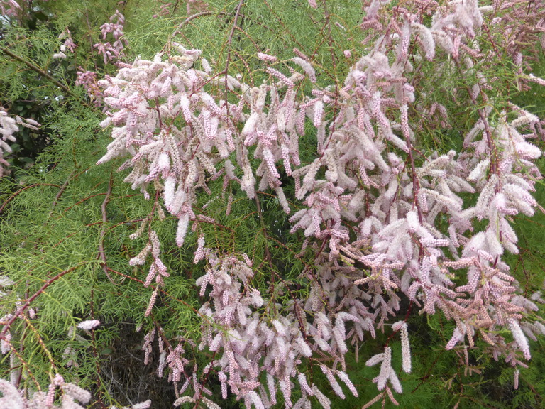
We stopped to admire the tamarisk which was in flower – a lovely soft pinky purple –  and to watch two kestrels hovering effortlessly in the strong wind just above our heads.

151024 Mawgan Porth to Padstow 14
Tamarisk in flower

The going had been sufficiently easy that we were considering revising our plan and to walk the extra distance to Padstow but, as we walked, we spied our hosts for the night and diverted with them to the generous comfort of Trevone for some rest and recuperation.

We had covered 12 miles in almost exactly four hours of easy going.

Part II

151024 Mawgan Porth to Padstow 27
Trevone

We picked up where we had left off the following morning, walking out of Trevone and once more up onto the high cliffs, passing another sink hole called, like its predecessor, by the simple and descriptive name ‘the round hole’. It was overcast.

Once again, the cliffs were high, solid and sheer. Below us the waves pounded against the cliffs making the ground we walked on feel as though it was shaking from their power.

151024 Mawgan Porth to Padstow 29
Above Butter Hole

Rising to Stepper Point, we passed a herd of bullocks, one of whom seemed to be contemplating a swift exit as he peered over the edge to a sheer drop of several hundred feet to the base of Butter Hole.

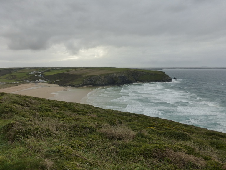
As we passed the point, the view over the broad Camel estuary opened on our right, the waves breaking far across the inland bay.

It was a little way from the mouth of the Camel to Padstow itself for the town is hidden behind yet another small headland: St Saviour’s Point which bristles with hidden fortifications which have been re-captured by nature.

151024 Mawgan Porth to Padstow 31
The Camel estuary from Stepper Point

Across the river, the dunes of Rock, St Enodoc and Polzeath beckoned us onwards but they were for another day.

We entered Padstow through the Chapel Style Fields, counting over 60 benches in a single long row, each named for some dear departed. It was hard not to agree that the view is well worth stopping and admiring but there was something depressingly municipal in the arrangement.

We headed for the church and a welcoming cup of coffee with friends. We had walked 5.2 easy miles in just under two hours. This is a lovely and classic stretch of north coast (except for the holiday park).

The rest of the day was given over to visiting other churches: St Merryn, St Ervan, St Eval and St Enoder.

Trenethick Barton, another church and some crosses

Trenethick 01
Trenethick Barton

A few hours to kill in Helston led us to walk to Wendron to study the church and its crosses.

A delight on the way was the discovery of Trenethick Barton, a fine C16 squire’s house with ‘an unforgettable two-storey gatehouse’ (Pevsner). The tall walls prevent one seeing much of the house.

Pevsner decribes it as ‘an exceedingly attractive ensemble of medieval house, gatehouse and courtyard walls, one of the best in Cornwall.’ This sounds pretty credible.

Trenethick 02
Trenethick Barton – the gatehouse

It would not be surprising to see the Warleggans or Poldarks leaving on horseback.

Freathy to Cremyll ferry

151010 Freathy to Cremyll 02Being a two day walk, we stayed in the area. This allowed us to make an early start which was lovely. The cool morning mist was still clearing, the sun breaking through the clouds and the clear early morning area filled our lungs as we set off from Freathy on our last leg of the south Cornish coast.

Trying to get a meal in a pub the night before we had been turned away from several pubs because ‘the wedding’. We never did discover whose but it was good to know that business was still brisk in October.

151010 Freathy to Cremyll 03The shack-land continued as we walked along the cliff beyond Freathy, the military road our constant companion, following the contours.  The open-air nature of these, with their little patch of green seemed so much more appealing and genuinely ‘green’ than the rows of houses at Looe, Millendreath, or Downderry. It was as though the planners were refusing brick and stone; well done them.

151010 Freathy to Cremyll 07In the distance loomed Rame Head and, tucked underneath it Polhawn Fort, scene of the big wedding. In no time, we were crossing the Iron Age ramparts and climbing the slopes up to the little chapel of St Michael on the headland. Here, the remains of a very exposed WWII anti-aircraft battery sat alongside a possibly Norman chapel within an Iron Age fort.

In the distance, the shadowy shape of another place – we think it must be Devon – stretched into the distance. Somewhere out there were Start and Prawle points, scenes of childhood memories for some.

151010 Freathy to Cremyll 11Shortly after the Head, we turned inland for a brief detour to admire lonely Rame church with its little spire and restrained woodwork.

Onwards, around Penlee point and the twin villages of Cawsand/Kingsand hove into view. Cawsand is dominated by the mighty bulk of a former fort, now converted to flats, which hovers like a spaceship over the tiny harbour.

151010 Freathy to Cremyll 15On the harbourside we admired the institute building, a smaller twin of that at Porthleven, which was almost undermined in the great storms of February 2014. From here it was a step to the former boundary (until 1844) between Cornwall and Devon at Devon-Corn house.

By now, we were all too aware that the colour of the geology had changed again. The familiar red sandstone of Devon was everywhere and  it was understandable why Devon once thought that this areas should be theirs. Despite the close-packed houses and narrow lanes, this no longer felt like Cornwall and the view of bits of the city in the distance hinted at the real loyalties of the area.

151010 Freathy to Cremyll 27An easy walk along low cliffs brought us to the last large fort at Picklecombe, which has been converted into flats and apartments in a way which betrays its original shape and feel.

Around the corner was the first sight of the city across the water as we entered the enormous Mount Edgcumbe park. The contrast between the close-packed houses, tower blocks and defences of Plymouth and the rural nature of the landscape through which we were passing, was very marked.

151010 Freathy to Cremyll 29We passed a succession of small ruins and follies and made another brief detour around the back of the less-than attractive red stone house before descending though incongruous and distinctly un-Cornish formal gardens.

From here it was a step out of the park to the Cremyll ferry where we rewarded ourselves with some lunch and well-deserved refreshment at the Edgcumbe Arms. We had walked about 9.5 miles in 3.75 hours of easy walking.

151010 Freathy to Cremyll 35And so we had reached the end of the beginning, or was it the beginning of the end? We had completed the south coast of Cornwall – but for one tiny bit of about 500m which remained on our consciences. Our attention will now turn once more to the unwalked sections of north coast which is said to be rather more in the ‘challenging’ category.

Looe to Freathy

151009 Looe 01
Looe from the east

Another series of social engagements and guests prevented us from making the most of some lovely September weather but we managed to get out for two consecutive days to complete the south coast.

We had left off our story looking at a loo in Looe and this is where we re-started our journey. It was October and we were not expecting scalding heat, a suntan or azure blue seas.

We had not altogether  taken to West Looe which appeared to straggle with little character. East Looe had a heart clustered around some narrow streets worthy of Mevagissey or Mousehole.

151009 Looe 05
Millendreath holiday village

Once we found our way out of town, we followed another straggly ribbon of houses along the cliff to Millendreath. This small beach was not an architectural gem having been colonised by a soulless holiday village of cheap houses.

A diversion – an unsafe cliff – took us through a narrow shelter belt of trees cunningly disguised to be woodland path and a short bit of road before we were once more on the cliff top, passing the monkey sanctuary.

151009 Looe 04
Looe island from Millendreath

The vegetation had changed since we had last walked. Now the dry brown leaves of oak, sycamore and beech were beneath our feet. The blackberries which had not been eaten by passing walkers, were coming to an end. The sloes were ripe on the bare wood of the blackthorn. Near houses, Michaelmas daisies were in full flower but the hydrangeas were coming to an end.

There was a distinct feeling that autumn was approaching. A weak sun shone all day: perfect conditions for walking.

151009 Looe 13
Rame Head

The sweep of Whitsand Bay to Rame Head would be our companion all day. It was one of those walks where you can see your start and finish points throughout the day. The underlying rock was slate which had created black and grey beaches rather than the golden sand we expected.

Our next stop was Seaton where we took the opportunity to sit on a seat and have our late morning coffee. Like Millendreath, it was not going to win many prizes for architecture.

151009 Looe 16
Portwrinkle

A long and glorious stretch took us to Portwrinkle. We had heard that it did not live up to its charming name but we found otherwise. The houses clustered around the tiny harbour seemed thoroughly traditional and well-cared for and good enough to excuse the straggle beyond. The hotel and golf course … well, there has to be a hotel somewhere.

Cresting a rise, we had our first view of distant Plymouth, a complete contrast to the rural landscape through which we were walking.

Before long we were being warned that we were entering a danger area. Approaching the Rame peninsular proper, one is constantly reminded how this area has been in the vanguard of defending Plymouth with a string of fortifications, batteries and forts from Palmerston’s time (1850s and 1860s) to World War II.

151009 Looe 21
Tregantle fort

The first and largest of these on this walk would be Tregantle. The cliff edge below this has been converted into a series of firing ranges. Thankfully, we were able to walk in front of the fort for there was to be no firing today.

Only a few mysterious and very much C21 semi-camouflaged objects suggested that this was a military site. They were gone by the following day.

151009 Looe 23
Freathy

It was only a step from here to our car, parked free at Freathy despite Cornwall Council’s conviction that we might want to spend vast sums in their car park.

Here there was a complete contrast to the straggle of Looe: a series of sheds or shacks clung to the cliffside at the top of a steep cliff, with some gentle waves breaking on golden beach below.

There was something simple and appropriate about these shacks which were almost universally in wood or look-alike wood. They felt like holiday cottages should, where life could be lived inside and outside with gorse and bracken as the garden wall.

We had walked 11 miles in 4.5 hours and felt good. Described as ‘strenuous, moderate in places’ in the guide we had felt it nearer ‘moderate’.

We headed off to find some churches: Hessenford and St Martin by Looe.